Tuesday, July 26, 2011

JULY 20 TO 26: THE LAST LOCKS AND ONTO GEORGIAN BAY

July 20:  We left Orillia on another calm but hot day.  After locking through Lock 42 at a mere 20 ft drop, our first challenge was to traverse the McDonald Cut which is another narrow, rock lined passage.   Luckily, no other large boats were coming in the opposite direction.

McDonald Cut-narrow but quite scenic.

A very narrow bridge at the end of McDonald Cut.
Our destination today is Lock 43 at Swift Rapids.  You can tell why it got its name:  there is a 47 ft drop.  We moored at the top of this lock for the night.  It is a very rural and quiet location.

July 21:  We met an adventurous Canadian couple at Lock 43 who are traveling the Trent-Severn Waterway in a large, motorized canoe.  Here they are at the top of the Lock behind us getting ready to Lock down. 

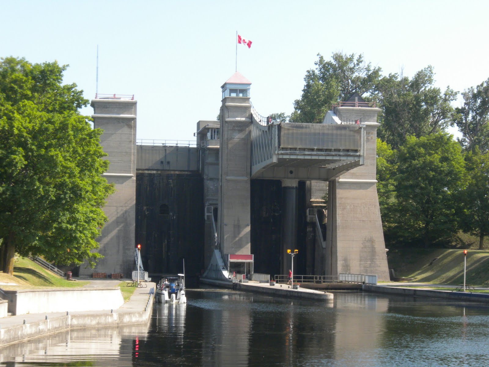
Onto our next exciting adventure:  Big Chute.  This is a marine railway.  Boats are lifted via a marine chute and transported over land to a body of water below to continue on the Trent-Severn.

The marine lift at the bottom of Big Chute.

Big Chute in mid air.

The Duddon Pilot entering the flooded marine chute.  Photos courtesy of Allan & Terry.


The Duddon Pilot suspended on the marine chute by slings.

The Duddon Pilot being lifted up 58ft.  Hold onto your hats!


The view from our boat as we are lifted over the road.  Not bad for a boat that generally needs water!

The view from our bow as we begin our descent.

The view looking back up the chute.  We are almost at the bottom!

After all the excitement of the Big Chute, we headed for our last Lock on the Trent-Severn Waterway.  We moored at the top of Lock 45 for the night and headed straight for a swim..today was so hot it broke records!  37 degrees Celsius which roughly translated is about 98F.

July 22:  After surviving the heat wave, we locked down our last lock on the Trent-Severn Waterway and headed for Georgian Bay.  Our first stop will be Midland.  Georgian Bay is also called the 30,000 Islands which is a misnomer as there are probably over 100,000. 
The most unique feature of Georgian Bay is the topography.  Land above and below the surface is granite-rocks everywhere.  While this makes for interesting viewing, it is challenging for boaters as the depths vary considerably.  The water can be 100 ft one minute and then drop off very sharply. 

To date, we have been traveling basically on a marine highway.  One has to follow the channel and the direction is predetermined.  Now we will really have to pay attention to our charts, GPS and keep a visual surveillance.  Fortunately, the channels are well marked for most of the routes.  It gets interesting when one ventures off into uncharted areas.

We were very fortunate to meet fellow Monk owners, Elena and Owen Smith who keep their boat, Suncee, in Midland.  They took us food and beverage shopping.  They have been cruising Georgian Bay for over 20 years and very graciously offered to guide us through part of the way and show us a few of their favorite anchorages.


Typical topography in Georgian Bay. It really is gorgeous.  Crystal Clear water..helpful to spot those underwater rocks!
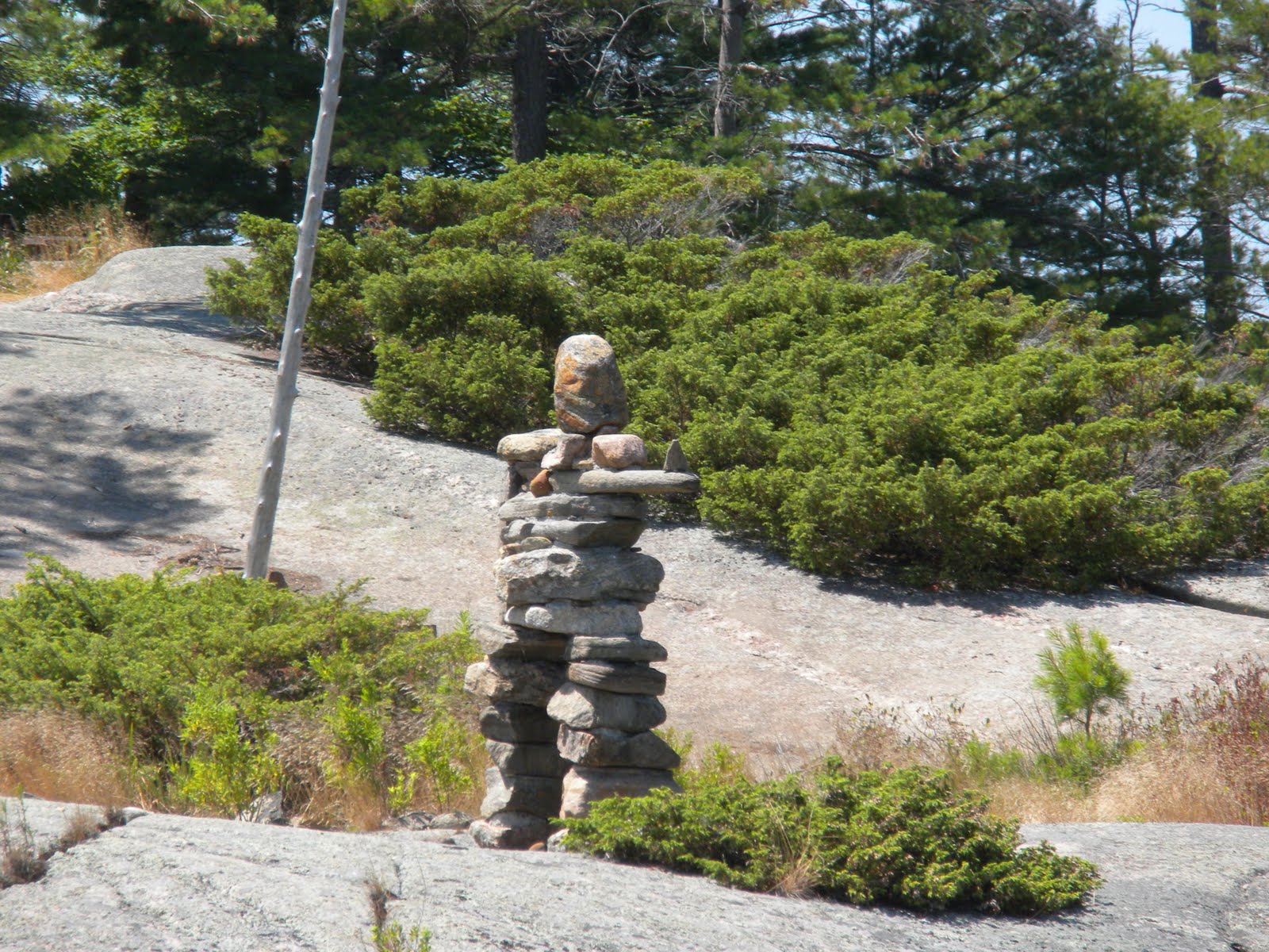
An Indian marker that was used to point the way for the early inhabitants of this land.

The Duddon Pilot rafted with Suncee, Owen and Elena's Monk in an anchorage off the beaten path.

Our dinghy taking his majesty ashore!

Elena's catch of the day and our supper! 

After spending three wonderful days with Elena and Owen, we took our leave and headed off on our own to Parry Sound.  We will provision there and then take off on our own to explore Georgian Bay.

Sunday, July 17, 2011

JULY 11 TO 18 LOVESICK TO ORILLIA

We have been having some difficulty accessing the Internet while in Canada so we can only update the blog when we have WiFi.

After leaving Young's Point, we crossed Stony Lake which gave us a preview of what to expect in Georgian Bay: Rocky hillsides and islands in crystal clear water.  This is where we would choose to live if we selected this region.

Examples of lakeside homes on Stony Lake-beautiful but probably pretty pricey!

Our next stop was at Lock 30-Lovesick.  Truly a beautiful spot.  It was so hot that we went swimming in the cool clear water.  The lock is actually on an island and is totally isolated and uninhabited-that is except for the raccoons.  We were advised by some Canadian boaters who were also at the lock that we should leave a plate of hot sauce out on the deck to discourage the raccoons from boarding the boat.    We did not follow their advice but were woken several times in the night by his majesty.  We thought that he just wanted a constitutional.  So Peter happily obliged him  at 2:00 a.m. and again a little while later.  In the morning, we learnt from the Canadians that the raccoons had indeed been on their boat.  They walked right through the hot sauce and left their foot prints behind.  They did board our boat, pushed the screen in above Gerbeaud's sleeping area but deterred by the vicious beast, left for more favorable hunting grounds on Glory Days

Joe and Pat on Glory Days woke to find two raccoons on their boat.  They pushed through their door screen and then opened the garbage can and were enjoying the lamb chop leftovers!  Joe backed off and fortunately so did the raccoons and they left.  They had crawled all over their couch and counter tops, leaving quite a mess. The next morning, Gerbeaud found one of the lamb chop bones that they dropped during their escape. 

We got a late start the next day as the gates at the lock at Lovesick were not operational.  By midday, however, we were on our way to Bobcaygeon for a two night stopover.  Bobcaygeon was unmemorable but we needed a laundry and grocery stop so it fit the bill.

Our next stop was Fenelon Falls.  A pretty little town at Lock 34.  The lock mooring area was renovated earlier this year and is the only lock on the system that has power and water available.  We thought it was worth it for the huge fee of $12.50 a night. 

Sunset at Fenelon Falls.
The moon setting at 5:30 a.m. at Fenelon Falls.  Peter took this photograph and no he was not three sheets into the wind!

After Fenelon Falls, we entered Balsam Lake which is at 840 feet is the highest point in the Trent-Severn Waterway.  After Balsam Lake, we entered the "Cuts".    They were the last part of the canal system to be completed in 1920.  The "cuts" were made through the Canadian Shield (solid rock) which is a geological feature throughout Canada.  This section is shallow and very narrow.
Entering the "cuts" from Lake Balsam.  Boaters are instructed to issue a security call when entering the cuts (or narrows as they are also called) to warn boats coming from the other direction.  We did encounter three oncoming boats going through this narrow section and it was rather hair raising!
The view from our bow going through the narrow channel.

After surviving the narrow cuts, we had to take a sharp turn onto Lake Mitchell.  If we thought the cuts were challenging, things really got interesting here.  The lake is very shallow and full of stumps.  Our depth gauge kept reading 3 and 4 foot depths and setting off the alarm-our boat draws 4.5 feet.  Fortunately, we did not hit the bottom and concluded that we were getting false readings as the lake is covered in weeds.

Next onto Kirkfield Lock.  This is another lift lock-49 feet.  This time, however, we are going down.  After driving into the pan, the sensation is similar to be suspended in water in mid air!
The view from our bow before we descend.  Not a good time to be sacred of heights.

Peter securing the stern line before the descent.

After going through a few swing bridges, our next adventure was the "Hole in the Wall".  The bridge was constructed in 1905.  Once through the "Hole", the channel narrows considerably and enters another lake that is overgrown with weeds.  Are we having fun yet?  We had to slow down and go into reverse a couple of times to dislodge the weeds from our propeller.  So far so good though.

Two more down locks today-all our locks will be down from now on.  Our final stop today was at Lock 39.  Another rural, isolated stop that we definitely prefer.  I should have mentioned before that the majority of the locks are operated manually.  This is a Canadian Parks employee closing the lock gate at Lock 39.  All the Canadian Parks staff have been exceptionally friendly and helpful.  One of the employees at this lock was driving into town and offered to buy ice for us.  An offer we gladly accepted.

After descending through another three locks, we entered Lake Simcoe.  The lake is 20 miles long and 16 miles wide and is the largest lake on the waterway.  It is advisable to cross the lake only in good weather as it can kick up waves up to 8 feet.  Fortunately, we had yet another great weather day.  We keep wondering when our luck will run out! 

Our destination today is the town of Orillia where we plan to spend three nights at the Port of Orillia marina.  We need to provision, do boat chores and most importantly review charts and plan our navigation route for Georgian Bay. 

We arrived in Orillia to the sound of Scottish bagpipes.  And you thought only William and Kate received a warm welcome!  There is a Scottish highland festival taking place for the next three days in the city park right next to the marina so we availed ourselves of the opportunity to hear the bands play.

They were really good but we felt their pain playing in 90 degree weather in those woolen kilts.

JULY 7-10 HASTINGS TO PETERBOROUGH TO YOUNGS POINT

After an overnight stop at Hastings to top off water and pump out, we headed to Peterborough where we plan to spend two nights.  With a population of 74,000, Peterborough is one of the biggest cites on the Trent-Severn Waterway.  We opted to stay at Lock 20 and not in the downtown marina. 

Lock 20 is located at a quiet residential area adjacent to a tree lined park with a walking trail around the lake.  Perfect for his majesty!  Prior to departure, we purchased a seasonal mooring pass for Canada Parks which allows us to moor at the Lock walls overnight. 

His majesty enjoying an early morning walk.  We do not need an alarm clock with him around-it's up and at it by 5:45.  With so much daylight, the early morning is the best time to take a long walk.  Gerbeaud is 12 years old and we were somewhat concerned about how he would handle being on the boat for so long.  So far, he is doing better than we expected.  He is quite adept at jumping off the boat on his own-even when he has not been given the okay!

Downtown Peterborough is just a short dinghy ride away.  This large fountain in the middle of the lake is active in the early evening.  The weather so far has been spectacular-we have had only two or three days of overcast weather with intermittent rain.  It has, however, been very hot.  Most days it has been in the high 80s with a few days hitting 90 plus.


Peterborough lift lock.  This lock is unique.  It was completed in 1904 and is the highest of its kind in the world.  It operates with two pans and weighs 1,300 tons when filled.  The two pans balance each other.  When one pan goes down, the other goes up.  Transiting boats drive into the down pan.  As boats displace their own weight, it does not matter how many boats enter each pan.
Boats in the down pan waiting to be lifted.  Each boat ties up to horizontal fixed lines and the pan lifts 65 feet.  The experience is similar to being lifted in an elevator (a water elevator!) and is  totally different to all the other locks.
This is us at the top of the Peterborough Lock-65 feet up!

Many Canadians travel the Waterway in house boats.  They have very shallow drafts. This is an example of one.

After our exhilarating lift at Peterborough, we traveled on to Young's Point at Lock 27.  Another quiet and peaceful lock.  Despite its rural location, it had an excellent restaurant at the top of the lock where we enjoyed a gourmet fish dinner.

The dam at Lock 27.


Wednesday, July 6, 2011

JULY 1-6 TRENTON TO CAMPBELLFORD: Back to Locking City!

We arrived in Trenton on Canada Day and were treated to an elaborate fireworks display that night.  Trenton is the first town on the Trent-Severn Waterway which will be our home for the next few weeks.

The Trent-Severn Waterway runs 240 miles from Trenton to Port Severn.  There are 44 locks in all.  Trenton is 243 feet above sea level.  We will be locking up until we reach Balsam Lake which at 840 feet is at the summit.  It will be downhill after that to Port Severn which is at 576 above sea level.

After two days in Trenton, we left in company with fellow l
Loopers Joe & Pat on Glory Days.

Glory Days approaching one of the six locks that we went through on day one.  The lock is to the right of the dam.

Typical entrance to a lock.  The approach has to be made slowly which can be a challenge for the Captain as the current can be quite strong due to the dam on the other side.

Glory Days entering the lock at slow speed.

Inside the lock after the gates are closed and before it is flooded.

At the top of the lock after we have been floated up.  We attach the boat to the steel cables on the side with short docking lines.  One midships and the other at the stern.


We stopped at the top of Lock 6 for the night.  The Canadian locking system requires one to purchase a lock and a mooring pass.  The mooring pass allows you to moor next to the lock walls overnight.

Lock 6 is in a very quiet, rural setting.  We relaxed and enjoyed a beautiful sunset.

After another night at Percy Reach at Lock 8, we arrived in Campbellford.  An early morning walk took us to the Ranney Falls Gorge and Suspension Bridge.

Gerbeaud was not too keen to cross the bridge.  I wasn't that keen myself!  We both made it over eventually and rewarded ourselves with some pastries from a great local bakery.

Campbellford is home to the artist who designed the two dollar Canadian coin known as the Toonie.

Limestone cottages really appeal to me.